In this article, we present five more lakes and lagoons in the central and southern provinces of Ecuador.
6 - La Mica
Laguna La Mica is located at the foot of the Antisana in the reserve of the same name in the province of Napo. It is about 40 km from the village of Pintag to the La Mica visitor center. There you register your details with the park ranger. The lagoon lies at an altitude of almost 4000 meters.
Mica is the name of a mineral that reflects sunlight. The lagoon is one of the sources of drinking water for the Ecuadorian capital Quito.
Activities. You can walk around or along the lake on various hiking trails and admire the snow-covered peak of Antisana. The path that circles the lagoon is about 3 km long and leads through a beautiful paramo landscape. A more challenging trail leads from the lagoon to the start of the glacier on the southern peak of Antisana. This route is about 20 km long and you should calculate 7-8 hours hiking time.
There is a visitor center with information at the entrance to the Antisana reserve. It is possible to camp in the area and fish in the lake, but only with permission from the reserve.
If you prefer cycling, there are great mountain bike trails along the lagoon.
Flora and fauna. The landscape is characterized by Paramo with a large variety of bird species such as the striped caracara and the Andean condor, which can also be observed with a bit of luck. Mammals include Paramo foxes, rabbits, deer and semi-wild horses.
What to bring. In addition to comfortable hiking clothing, you should bring a hat and a windbreaker, as it can get quite chilly as soon as the clouds roll in. You should also take enough water and snacks with you, as the local shopping facilities are very limited.
7 - Limpiopungo
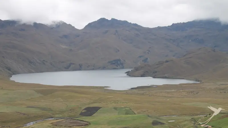
The Limpiopungo lagoon is located in the province of Cotopaxi in the Latacunga canton at an altitude of 3800 meters. It is part of the Cotopaxi National Park. It is located directly on the route to the Jose Ribas refuge and, with the volcanoes Cotopaxi, Sincholagua and Rumiñahui in the background, it is probably one of the most popular photo motifs in Ecuador.
The lagoon was formed as a result of eruptions of Cotopaxi, when ice and snow caps came into contact with lava or pyroclastic flows and melted. However, the lagoon is getting smaller and smaller as water is constantly being diverted for irrigation purposes. As a result, large parts of the shore are now marshy and overgrown with cattails.
Activities. The lagoon is an excellent photo opportunity at all times of the day and year. In the morning, when there is little wind and the sky is still blue, you can capture the reflection of the volcano in the lagoon. At other times of day and in the winter months (November-April), the lagoon and the volcanoes glow in various shades of silver. The lagoon is a popular stopover before or after a visit to the Cotopaxi volcano.
Flora and fauna. The lagoons of the Paramo landscape are fed by a sponge-like soil that absorbs rain and mist water. The area surrounding the lagoon is rich in flora and fauna, including wolves, deer, pumas, rabbits, caracaras and wild horses and typical Paramo plant species.
What to bring. Due to the altitude, you should be prepared for cool temperatures in terms of clothing. On the other hand, the high altitude sun should not be underestimated, so sun protection and headgear should also be considered. Shopping opportunities in the area are very limited. You should therefore take plenty of water and snacks with you.
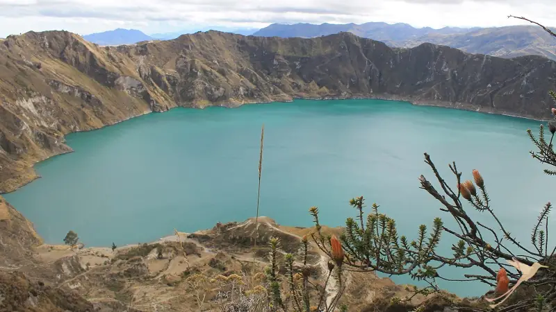
8 - Quilotoa
The lagoon is located in the province of Cotopaxi directly next to the small mountain village of Quilotoa, approx. 76 km west of Latacunga.
The crater lake was formed by a huge eruption of the volcano of the same name, as a result of which the caldera filled with water. It is up to 250 m deep with a diameter of around 3 km. Due to minerals and depending on the light conditions, the color of the water changes between green, turquoise and blue.
Quilotoa is a popular destination for travelers because the panoramic view over the crater lake is spectacular, no matter where you are on the crater rim.
In Kichwa, Quilotoa means “princess diamond” and there are also numerous myths surrounding this lake. According to legend, two gods lived in the volcano and when they quarreled, an eruption occurred.
Activities. You can visit the viewpoint from the village of Quilotoa. Here you can enjoy the wonderful panoramic view over the lake. Near the viewpoint, a hiking trail leads down to the lagoon. The hike takes about 3 hours there and back. Alternatively, horses can be hired for the descent and ascent. You can camp by the water and take a kayak tour on the lake. It is also possible to walk around the lake along the crater rim. The route is around 12 km long. You will pass a second viewpoint, the Shalala viewpoint, the front of which is made of glass. A complete circuit takes 4-6 hours, depending on your fitness level. As the highest point is at almost 4000 m, you should have acclimatized beforehand and be able to cope with the altitude.
Another option is the so-called Quilotoa Loop. On this multi-day circular hike, you will get to know the landscape and the villages around the crater lake. This tour is best undertaken with an experienced guide, as the route is hardly signposted in places.
Flora and fauna. The landscape around Quilotoa is very rugged and characterized by grasses and ground cover plants, some of which are used medicinally. There are also a few shrubs and some eucalyptus trees. With a bit of luck, foxes, rabbits and deer can be observed among the mammals. Buzzards, wood pigeons and great titmouse can be seen.
What to bring. Due to the altitude of almost, 4000m, there are considerable temperature fluctuations between day and night. The Andean sun shines very strongly during the day, and you should definitely wear headgear and/or sunglasses and apply sun protection. A wind and rain jacket and sturdy, comfortable shoes are also recommended. Don’t forget enough water and possibly a snack, as there is no opportunity to buy anything along the route. There are no ATMs in Quilotoa and only some card payments work, which is why you should have enough cash and small change with you.
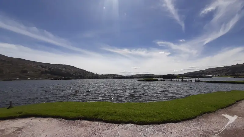
9 - Colta
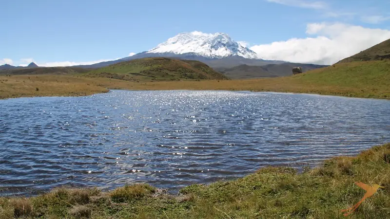
At an altitude of around 3,400 meters above sea level, Colta stretches over an impressive area. It is one of the oldest lagoons in Ecuador and is characterized by its elongated shape and clear, calm waters that reflect the Chimborazo volcano. It is around 275 hectares in size and was formed by geological processes and tectonic activity. Its direct location at the Panamericana makes it one of the most accessible lagoons. It is about 20 km from Riobamba.
Its name means Laguna del Pato – duck lagoon – which refers to the abundance of ducks around the lagoon.
Activities. The Colta Lagoon offers a variety of activities for visitors. Hiking along the shore, bird watching and photography are popular activities to enjoy the natural beauty. Kayaking and fishing are also available at the lagoon. Colta Lagoon is not only a place of natural beauty, but also a testament to Ecuador’s rich culture and history. A visit here not only offers the opportunity to explore the breathtaking landscape, but also to immerse yourself in the deep traditions of the local communities. For example, you can visit the Balbanera church, the first church built by the Spanish in Ecuador.
Flora and fauna. The flora and fauna around the Colta lagoon are diverse and characterized by the surrounding paramo landscape. The reed grass Totora grows on the shores, which is still processed by hand today. Other plant species include polylepis trees and quinua is cultivated in the surrounding area. The Colta lagoon is an important habitat for water birds such as ducks, gulls and other species. The region is also frequented by migratory birds. The lagoon is home to diverse and colorful fish species that maintain the ecological balance in the water. Various reptiles and amphibians can be found on the shores of the lagoon.
What to bring. Due to the changeable climate, it is advisable to bring layers of clothing so that you can adapt to all weather conditions. Temperatures fluctuate between 12 and 15 ° C on average. Hiking boots, rainwear, sun protection, sufficient water and snacks are also recommended.
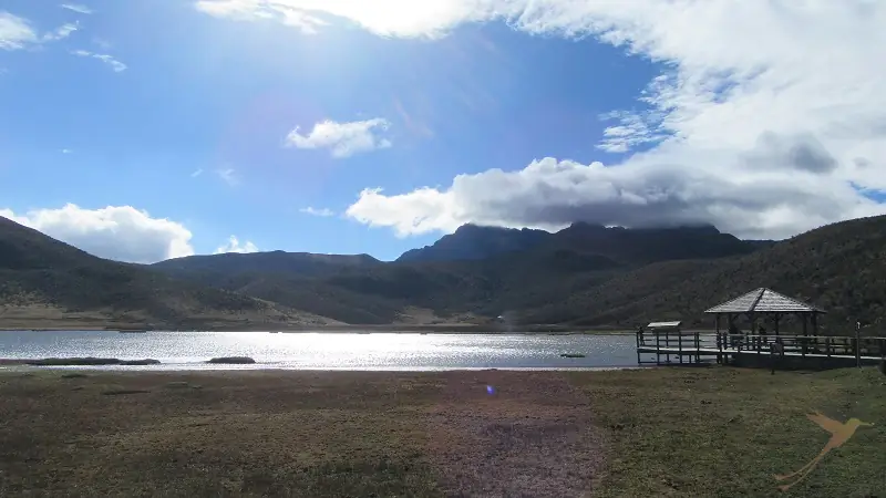
10 - Ozogoche
The Ozogoche lagoons are one of the tourist attractions of Alausi. They form a system of 45 lagoons or lakes in the Sangay National Park, 20 km south of Guamote and 36 km east of Palmira and 90 km from Riobamba. A magical destination that offers peace, tranquility, pure air and direct contact with nature. At night you have the feeling of being closer to the stars.
The lagoons are deep, cold and a striking dark blue color.
The name Ozogoche comes from the Jíbaro: ushu, greedy for flesh, and juchi, to be alone; the etymology goes back to an indigenous legend that says that the birds known as cuviví throw themselves into the water to die, paying a suicidal tribute to the sacred lagoons.
Activities. One of the most popular and well-known aspects of the Ozogoche lagoons is birdwatching, especially because in mid-September there is an event that usually amazes and confuses those who come to the area.
It is the migration of the “chorlitos” (cuvivi in quichua), a bird species that attracts a lot of attention due to its unique beauty. They reach the lakes to end their lives in a natural death struggle known as a tribute. Hundreds of these animals systematically plunge into the icy waters of the lake without warning.
The reasons for this process have not yet been explained. However, there are speculations that it is because the cuvivís are fatigued and impaired by the heat. When they see the water, they plunge in looking for something to quench their thirst, but the low temperature kills them immediately.
The Ozogoche lagoons offer opportunities for hiking, sport fishing, meeting indigenous communities, photography and adventure. In their surroundings there is a large area for camping and mountain biking, and you can visit mountains such as Soroche, Sasquín and others that form the Achipungo mountain system.
Flora and fauna. The flora is characterized by Buddleja, Polylepis, Pumamaqui (Oreopanax ecuadorensis), Andean flower. Ozogoche is a habitat for spectacled bears, Andean condors, pumas, deer, Andean gulls, ducks, caracaras, deer and sheep.
What to bring. Temperatures fluctuate between 20° C during the day and can drop to below 10° at night. It is therefore best to wear layers of clothing. Also remember to bring sun protection, a hat and plenty of water and snacks.
Are you interested in getting to know the lakes and lagoons of Ecuador? Many of them are part of our different tours. But of course, we can also organize an individualized trip for you to visit one or more of the lakes. Get in touch with us, we will be happy to help you.